Environmental chemistry: water testing as part of collaborative project work Teach article
Wetlands are key habitats for a vast range of wildlife. Richard Harwood and Chris Starr, from Aiglon College, Switzerland, describe a school project to measure water quality in a local wetlands region.
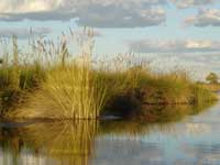
Delta – one of Earth’s most
unique wetlands
Environmental issues centred on water are among the key concerns in our modern world; the global problem of disappearing wetland regions is particularly significant. Wetland regions are key habitats in the preservation of a vast range of wildlife species, and the health of such regions is an important indicator of the health of the ‘blue planet’. The past 50 years have seen the earth’s wetlands reduced by around 50%.
Concern over wetland regions provides part of the background to a series of cross-curricular studies that we have carried out at Aiglon College, an international school based in western Switzerland. The collaboration between our geography and chemistry departments in carrying out these studies was also seen as important, emphasizing the interaction between the skills and methods involved in the two subjects. The studies were carried out by students in their final two years of secondary school.
Aiglon’s location close to the eastern end of Lake Geneva allows us ready access to a small, but highly significant, wetland region at the delta of the Rhone where it flows into the lake. This region of Switzerland is experiencing rapid urbanisation and the development of services for the tourist industry, which are putting increasing pressure on the few remaining natural habitats of the Rhone plain. The delta wetlands area, known as Les Grangettes, is rich in wildlife, featuring a great diversity of reptiles, amphibians, invertebrates and birds. Around 265 bird species have been identified in the reserve, including many migratory waterbirds. Since 1990, the area has been recognized as a wetland of international importance under the Ramsar Convention, but it is still threatened by the encroachment of human activities and modifications of the natural environment, whether intentional or unintentional.
The scope of the studies
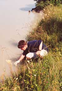
canal
Our studies of this region included a range of approaches involving land use surveys, an analysis of the impact of tourism, biodiversity data collection and the assessment of water quality. To carry out a thorough study of water quality, it was important to strategically choose the points in the area to collect water samples. Water samples were taken from some 24 different sites in the Les Grangettes region, covering a range of different locations – canals, drainage ditches, lake frontage and stagnant pools.
We tested water for a range of parameters, such as:
- pH
- dissolved oxygen
- nitrate ion concentration
- phosphate ion concentration
- turbidity
Some of these tests were carried out immediately in the field, but these were also followed up with more sophisticated testing back in the lab.
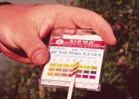
in both the field and the lab.
A range of equipment was
used, from pH strips to
datalogging sensors
The type of testing that we carried out varied from simple test strip methods for pH and nitrate ion concentration to electronic sensing (for dissolved oxygen and turbidity, for example), reflectometric reading of test strip colours (for nitrate and phosphate ion concentration), and the use of specific ion electrodes (for nitrate ion concentration).
The electronic sensors were linked to data-logging instruments and electronic calculators. The use of this range of methods not only served to check the reliability of the methods but also introduced the students to the different levels of sensitivity available for measuring these factors.
A major focus was to assess whether fertilisers were leaching from surrounding agricultural land into the protected area. Such leaching would result in eutrophication and its consequent impacts on the ecology of this environmentally sensitive area. There are strict local restrictions on farmers in the immediate area and we were able to link our data with that from the Grangettes Foundation, the organisation responsible for the management of wildlife conservation in the protected area.

The analysis of the data from these tests is of crucial importance in increasing the usefulness of the study. Applying valid statistical methods to the analysis of the results is important in establishing their meaning. One aspect of our studies that has produced revealing results on statistical analysis was the testing of nitrate levels. The choice of the most appropriate statistical test is key here, and, as with the use of practical techniques of differing sensitivity, this gives students a useful insight into research techniques.
Statistical analysis of nitrate ion results
Our aim was to see if there was any relationship between nitrate concentrations and agricultural activity at different sites. We first conducted a straightforward rank correlation test (Spearman’s, see box) using all of the data. The test was used to see if there was any correlation between the distance from the nearest arable land and the nitrate content of the water sample. The results showed no apparent correlation.
This led us to consider the different nature of the sample sites more closely. Lakefront sites, part of the large body of water that is Lake Geneva, were likely to have very low nitrate levels through dilution when compared with, say, drainage ditches. Lakefront samples were therefore discounted and the other sites were then examined more closely. A pattern did emerge when the origins of the water in the channels and ponds within the reserve were analysed. The water in some sites had its origin within the boundaries of the reserve, while other channels flow in, bringing water that has drained land outside the reserve boundaries. When the results were interpreted with this added information, it appeared that all the sites that had measurable nitrate ion concentrations contained water originating from outside the reserve (see Table 1). On the other hand, water bodies and channels originating within the boundary of Les Grangettes showed no measurable concentrations of nitrate.
The reliability of this apparent difference was tested using the Mann-Whitney U-test (see box). The results of the Mann-Whitney test indicated a less than 5% probability that the differences observed between the two types of site could have occurred by chance. There was more than a 95% probability that the difference observed between our samples originating within and outside the reserve reflected a wider pattern.
Concluding remarks
The discovery of a statistically significant difference between the two types of site was important for two reasons. It was supported by our subsequent finding, in an interview with the Director of the Grangette Foundation, that there are very strict regulations on the use of fertilisers by arable farmers within the reserve, whereas such restrictions do not apply to farmers outside the reserve. The local farmers seem to abide by these regulations. Secondly, the students’ reactions to successful data collection and analysis were encouraging; it gave us and them much pleasure to apply skills from different subject areas to real-life situations.
A number of students took part in different aspects of these studies, and the methods and results formed the basis of successful examination projects for students taking chemistry and/or geography courses.
Water analysis techniques can be applied to a variety of local situations and there are useful websites and Internet-based projects that can be accessed to give further dimensions to local studies. Two such sites are those of the GLOBE Programw1 and the Global Water Sampling Projectw2.
Statistical analyses
The purpose of the statistical tests used is described below. Details of how the tests are performed can be found in Lenon & Cleves (2001).
Spearman’s Rank Correlation Coefficient
This technique is used to summarise the strength and direction of any correlation between two variables, such as nitrate [NO3-] content of water and distance from arable land. The correlation coefficient (numerical index of correlation) varies from +1 (a perfect positive correlation) to -1 (a perfect negative correlation). A value of 0 indicates no correlation between the two sets of variables. The greater the sample size and number of measurements, the more significant the correlation is likely to be. Its significance can be tested by using a test of significance, such as the t-test.
Remember, this coefficient does not necessarily prove a causal relationship between the variables. However, it may suggest that it is worthwhile conducting further research to uncover the processes which may have led to the correlation.
Mann-Whitney U-Test
This is a test of statistical significance, used to establish whether the differences between two sets of data are really significant or could have occurred by chance. For example, here we are trying to establish whether there is a significant difference between the nitrate [NO3-] content in water bodies originating inside the nature reserve, where strict controls on the use of fertilisers exist, and that of water originating outside the reserve, which is likely to have been more affected by arable land uses.
Remember, if we find that there is a high probability that the relationship between the data sets could have occurred by chance, it may indicate that there is no significant difference between the data sets. However, it could also reflect the fact that our sample size was too small to produce a significant result.
A statistically significant difference between data sets is obviously a starting point for further investigation into the processes which may have led to these differences.
References
Web References
- w1 – GLOBE Progr
- w2 – Global Water Sampling Project
Resources
- AquaData, a school project using five different methods to measure water quality (German)
- Information about measuring river quality, including results for your local (UK) area, can be found on the UK Environment Agency website
- The Water Quality Standards Handbook from the US Environment Protection Agency
Review
This article is an example of good practice for secondary school teachers interested in a scientific approach to environmental education. It is interdisciplinary, involving chemistry, earth sciences, statistics, and a heuristic methodology; focuses on a real situation; and demonstrates the transferability of the situation and the methods used in the study.
The style is plain and clear, so the material can easily be used in lower grades in secondary schools with only minor simplifications.
The web references will enable interested teachers to find further information and guidance to plan similar experiments in their own countries.
Giulia Realdon, Italy