


Forecasts from orbit Understand article
Aeolus – a new laser-equipped satellite – is designed to give meteorologists the comprehensive wind data they need for better weather forecasting.
Checking the weather forecast on our phone, computer, radio or television is part of daily life. Weather forecasts are important for planning our day-to-day activities – and they are also vital for numerous sectors such as transport, agriculture, commerce and industry. The economic and social benefits of accurate weather forecasts are huge: they give us the information and time necessary to prepare and make decisions, whether these are about gritting the roads, deciding routes for air or marine traffic, irrigating crops, or planning construction work. In the extreme, knowing that hazardous weather is on the way can help us protect property and save lives. But what role does scientific knowledge of our planet have in such predictions?
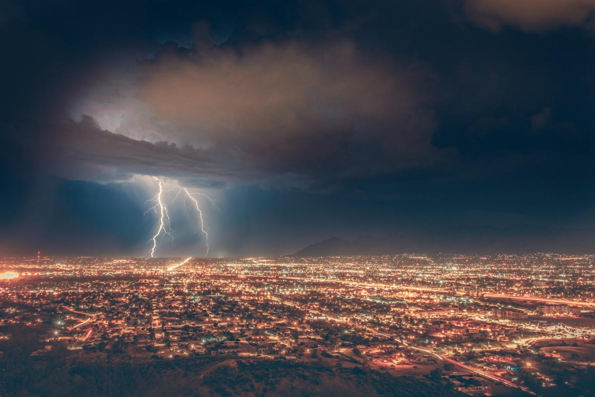
Michael Rogers/Unsplash.com
Bringing in the data
Creating weather forecasts is a complex process that involves collecting as much measurement data as possible about the state of the atmosphere – particularly temperature, pressure, humidity and wind. This data is obtained from a global network of weather stations and other monitoring sources, from weather balloons to ships and scheduled airlines – and also satellites.
Attempts to forecast the weather go back to the time of the ancient Greeks, but the systematic collection of information to use in weather forecasting started in the 19th century. The advent of the satellite era around 50 years ago has led to enormous improvements in the accuracy of weather prediction and our understanding of climate. Today, about 90% of data used by numerical weather models comes from satellites. This includes global observations of snow and ice, microwave and infrared radiances, winds derived from motion of the sea surface, and clouds. Data remotely sensed by satellites, along with other measurements, is used in numerical prediction models, which are run on supercomputers in meteorological centres around the world to forecast the weather. For example, the weather forecasting system at the European Centre for Medium-Range Weather Forecasts (ECMRWF) in the UK processes 40 million individual observations every day and integrates this data into their weather model.
Highs and lows
Forecasts rely on data from satellites in two different types of orbit, which offer complementary perspectives of the Earth and evolving weather systems. Satellites in geostationary orbit hover around 36 000 km above the equator, while satellites in polar orbit circle the Earth above both poles at the much lower altitude of a few hundred kilometres above the surface.
The high-altitude geostationary orbit allows a large portion of Earth’s surface to be in constant view. For example, Europe’s geostationary Meteosat weather satellites constantly observe Europe and Africa, while the USA’s NOAA GOES satellites do the same for the Americas. This high vantage point enables rapidly evolving events to be monitored continuously, providing advance warning of continental-scale thunderstorm fronts, hurricanes and other destructive weather phenomena.
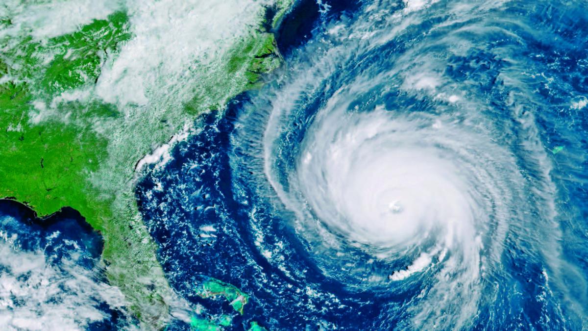
NOAA, CC0
However, there are some parts of the planet that geostationary satellites never view, and their greater distance from Earth’s surface limits the resolution of their data. In contrast, polar-orbiting satellites collect data over the entire planet in a matter of days, and their lower orbit yields much higher-precision data than can usually be gained from the high geostationary satellites. There are a fleet of weather satellites operating in polar orbits, including Europe’s MetOp and the USA’s JPSS satellites.
Room for improvement
Although our weather forecasts are more accurate than ever before, there is still the wish to improve them further, especially for long-range forecasting. The chaotic nature of the atmosphere, and the need for a more detailed understanding of the processes involved, mean that there is a constant drive for new information. This will not only help forecasting, but also aid our scientific understanding of how the atmosphere works and the longer-term implications of climate change.
Over the past few decades, meteorologists have argued that, in particular, there is a lack of accurate global wind data, which is needed to improve forecast accuracy. In response, the European Space Agency (ESA) launched a new satellite in 2018 specifically to provide better wind information. The satellite is named after Aeolus, who in Greek mythology was appointed ‘keeper of the winds’ by the gods. So how will this satellite help with forecasting?
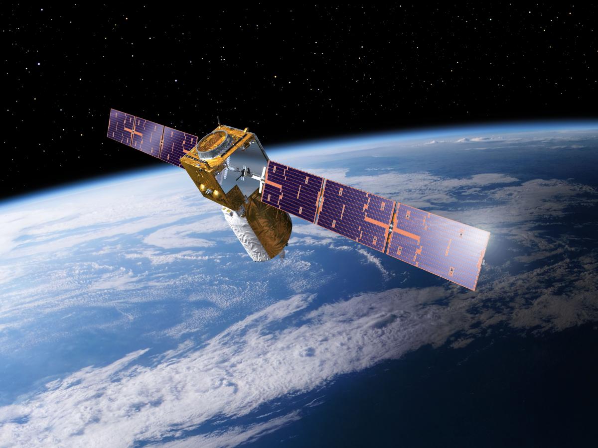
designed to acquire wind
data from across the globe,
using innovative ‘lidar’
technology.
P Carril/ESA
Wind profiles are an essential element of accurate medium- to long-term weather forecasting, as well as a key input for modelling climate change. This is because the wind is an important component of the Earth’s energy balance. Essentially, some areas of Earth receive more heat from the Sun than other areas, leading to differences in air temperature, density and pressure. These differences in turn cause the air to move, creating wind. Wind transports heat away from equatorial regions towards the poles and returns cooler air to the tropics. The Earth’s rotation also results in large-scale wind systems such as the jet stream. These effects form the basis of atmospheric circulation, which governs the weather and climate.
There are a variety of sources that provide wind information: weather stations, weather balloons or aircraft, and satellite observations of moving clouds and ocean roughness. But until recently, large parts of the atmosphere were not well observed – in particular, the tropics, over the oceans, in the southern hemisphere, above polar regions (where there are few weather stations or balloons) and in the higher atmosphere. Direct wind observations covering the full extent of the atmosphere – both horizontally and vertically – were therefore needed to better predict the weather.
The Aeolus satellite is equipped with breakthrough laser technology (see text box). This allows wind fields to be mapped globally up to an altitude of 30 km for the first time, including in areas that are not well covered by existing observation systems. This height includes the troposphere, where the weather that affects our lives is formed. Although the mission is scheduled to last only three years initially, Aeolus is expected to lead to a new generation of satellite instruments designed for routine weather forecasting.
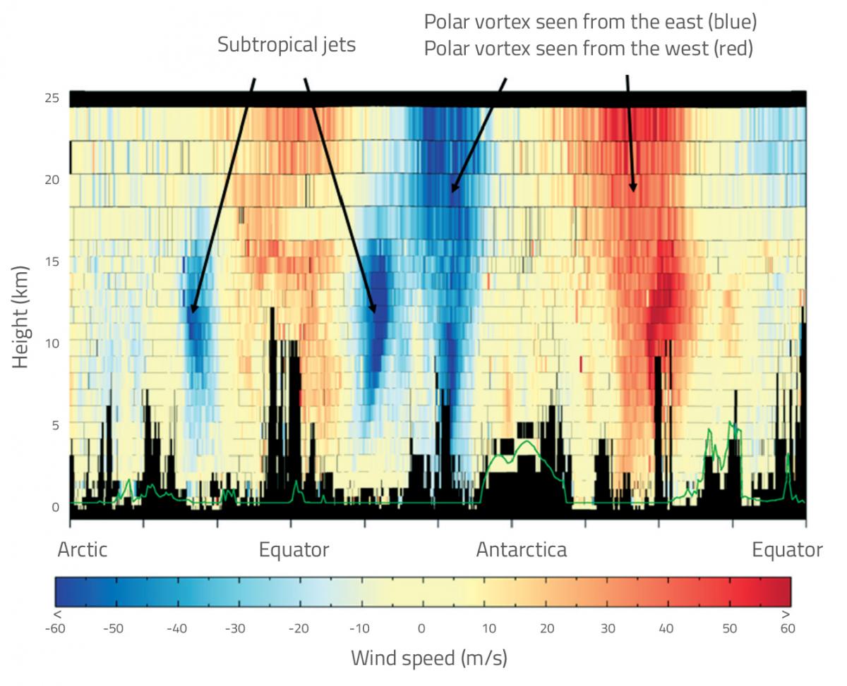
ESA/ECMWF
Beyond weather forecasting
Satellite data is becoming increasingly important in many everyday applications other than weather forecasting. With air pollution a major environmental health problem, daily forecasts now often include warnings on poor air quality, and satellite data is used to ensure that these forecasts stay as close to reality as possible. For example, the EU’s Copernicus Sentinel-5 Precursor satellite maps a multitude of pollutant gases such as nitrogen dioxide, methane, carbon monoxide, ozone and sulfur dioxide. This satellite gives decision-makers the information they need to fight air pollution and also provides data to help scientists understand atmospheric processes linked to climate change – for example, why holes form in the stratospheric ozone layer.
To monitor our changing world in the light of climate change, satellites track changes in many factors: the dynamics and composition of the atmosphere, ice cover and volume, the height and temperature of the sea surface, the way land is used and urbanisation, and more. This is the only realistic way of observing the Earth as a whole and generating the information we need to understand how Earth works as a system – and, of course, the impact humans are having on natural processes.
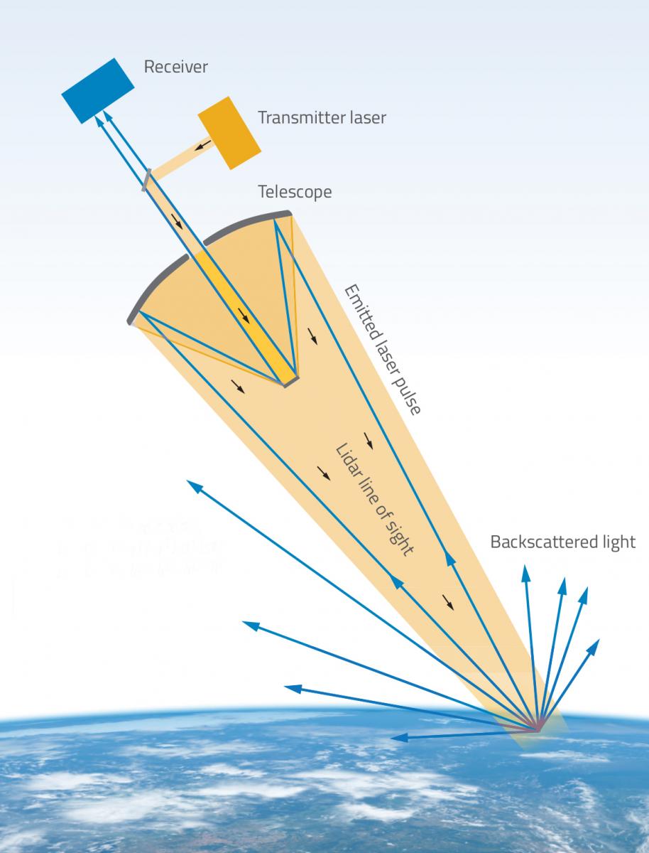
Aeolus: lasers in space
technology that is used
onboard Aeolus (click image
to enlarge)
ESA/ATG medialab/Nicola Graf
Launched on 22 August 2018, the Aeolus satellite carries one of the most sophisticated instruments ever to be put into orbit. At the heart of Aeolus is a highly sophisticated Doppler wind ‘lidar’, which can be thought of as a laser (i.e. light) radar. One of the aims of the Aeolus mission is to test this novel technology – which comprises a powerful laser, a large telescope and a very sensitive receiver – in space.
From its 320 km high orbit, the laser emits short but powerful pulses of ultraviolet light (355 nm wavelength) 50 times per second. This light travels down through the atmosphere, and a tiny fraction is backscattered from particles moving with the wind – air molecules, dust, ice particles and droplets of water. The backscattered light is collected by the telescope and detected by the receiver, which is incredibly sensitive: it can pick up as few as four photons per metre, along the line of the laser beam.
Just like the radar that police use to catch speeding motorists, the backscatter from the moving particles results in a small ‘Doppler shift’ between the light frequencies that Aeolus emits and receives back. From this shift, the wind velocities along the satellite’s direction of view can be derived, to an accuracy of some 2 m s-1.
Resources
- Learn more about the mission of the Aeolus satellite on the ESA website.
- Learn about the roles of satellites in numerical weather prediction with an interactive module from the European Centre for Medium-Range Weather Forecasts (ECMWF).
- The European Organisation for the Exploitation of Meteorological Satellites (EUMETSAT) operates a complement of meteorological satellites to monitor the climate and developing weather situations. Learn more about its mission and activities on the EUMETSAT website.
- Watch a short video from the UK’s National Meteorological Service explaining how weather forecasts are created.
- Resources to teach students about monitoring Earth and its climate are available on the ESA Education website.
- The EO Browser and Sentinel hub are online tools that allow all users to access current satellite images. Learn how to use the EO Browser from the user guide.
Institutions
Review
Precise weather forecasting is becoming more and more important for our life on Earth – given climate change and increasing temperatures, both globally and regionally. For more precise forecasts, new satellites such as Aeolus are being developed and launched into space.
This article could be used for teaching many different topic areas, from the environment to optics and engineering. The following questions could be included in a comprehension exercise:
- Why is weather forecasting so important for our daily life? Give some examples.
- How does weather forecasting work today?
- Why does most weather forecasting data come from satellites?
- Name some weather data satellites that are in space now.
- Why is information on wind systems so important for our weather?
- What is lidar, and how does this system work?
Gerd Vogt, physics and technology teacher, Higher Secondary School for Environment and Economics, Yspertal, Austria